


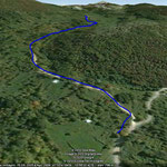
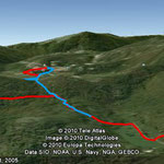
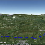
Path 1: Fontana Vecchia-Pozzo della Pinchiera a
- Height difference: (from 782 to 868 m.a.s.l.): 86 m
- Length: about 1.12 km
- Duration: 30 minutes approx.
- Degree of difficulty: easy
- CAI Rating: T
Download the trail and view it on Google Earth:
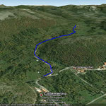
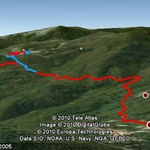
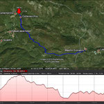
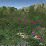
Path 2: Casale - Viticuso
- Height difference: (from 863 to 758 m.a.s.l...): 105 m
- Length: about 6.80 km (red trace)
- Duration: 1 hour 45 minutes approx. (red trace)
- Degree of difficulty: medium
- CAI Rating: T
At about 2.95 km from Casale (at 3.85 km from Viticuso - red track) you can follow two different trails to reach the center of Viticuso, the blue one is 1.8 km long or you can go on the red one of about 3,8 km using the last part of Viticuso bike path.
Download the trail and view it on Google Earth:


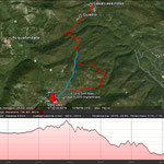
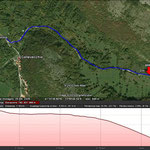
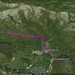
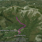
Path 3: Fontana Vecchia - John Mastro
- Height difference of first part (from 780 to 809 m.a.s.l.): 29m
- Length of first part: about 1.12 km
- Height difference of second part (from 809 to 735 m.a.s.l.): 74m
- Length of second part: about 3.16 km
- Overall length: 4.28 km
- Duration: 60 minutes approx.
- Degree of difficulty: easy
- CAI Rating: T


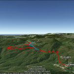
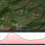
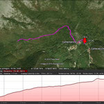
Path 4: Fontana Vecchia - Bivio Strada
- Height difference (from 779 to 932 m.a.s.l.) 153 m
- Length: about 1.77 km
- Duration: 40 minutes approx.
- Degree of difficulty: easy
- CAI Rating: T
Download the trail and view it on Google Earth:
At this link you can download the program Google Earth:
http://www.google.com/intl/it/earth/download/ge/agree.html
Classification according to Track CAI:
T - Pedestrian route on roads, cart tracks (dirt roads used mainly by farm wagon), mule or obvious paths (path of touristic interest)
E - Route without technical difficulties (generally equal to or mule trails or to access to shelters or linking with near valleys)